 |
| This is an ancient map drawn during the Han Dynasty (206BCE-220CE) taken fromhttp://bbs.godeyes.cn/showtopic-33672.aspx. Although the conditions of this map are poor, we can still see the distinctive features shown including specific places and the landscape features surrounding them. This map is one of the earliest maps found in China and it was drawn on silk. According to experts, this was used as a military map and we can see that the coverage of the landscape is quite broad, suggesting that people, more than two thousand years ago had the ability to make sense of their environment to locate places and navigate in a large space. As we can see, there are boxes-like, circular-like, and curve-like features on the map. The boxes might represent bounded areas like cities with city walls. The circular features might be other military bases, and the wave like features might be mountain ranges. There is no evidence showing that it is a scaled map, but the relative locations of places with nominal markers in addition to the cardinal directions can allow the readers of the map to navigate through different features on earth's surface. This map interests me a lot because of the abilities of the people to create such complex maps within a large space without ariel photographic or detective technologies. It is also interesting to note that the reason for making such map was for a military purpose. When the people were really engaged in a war with other states at that time, the leader, leading such a huge group of soldiers through such intricate landscape, must really be able to comprehend what was going on in the 2D space and relate it to the 3D space around. In addition to this, it was really important for the person who drew the map to be really accurate. |
 |
| This map is a map of Hong Kong, China taken from http://wpcontent.answcdn.com/wikipedia/commons/thumb/6/68/Map_of_Hong_Kong.svg/400px-Map_of_Hong_Kong.svg.png. Hong Kong is divided into 3 main regions - due to historical jurisdiction (Hong Kong as a British colony) and governmental control reasons - namely The New Territories, Kowloon, and Hong Kong Island and is further subdivided 18 districts (as shown on the map) for better control of the people living in the areas by each of the district governors. As we can see from the map, the New Territories districts are clustered in the Northern area of the whole of Hong Kong, Kowloon districts in the middle, and Hong Kong Island districts further South. And all these 18 regions are separated on the maps by gray borderlines to show their distinctive areas. Having lived in Hong Kong for all my life, I have never really seen the clear border marked on any landmarks or features to separate the different districts for example 5. Sha Tin and 6. Tai Po, all they have is a small sign saying "Welcome to Tai Po" when going from the Sha Tin direction to the Tai Po direction or "Welcome to Sha Tin" when going from Tai Po to Sha Tin, but these signs are separated a long distance apart from each other and it is really hard to tell when standing in between those signs which district you are in. It is only through this map or even more detailed ones showing where exactly the border is to determine where we are in Hong Kong. However, all these are determined and controlled by the government and also the department in control of all the aerial information of Hong Kong and it might be marked with slight distinctions on different maps. For me, I live in Sha Tin near the border of Tai Po, therefore I have no problem in answering census or any governmental documents asking which district I live in. But people living "between the signs" or "right on the border" of two different districts, it might be up to the government to decide which district they belong to. |
 | |||||
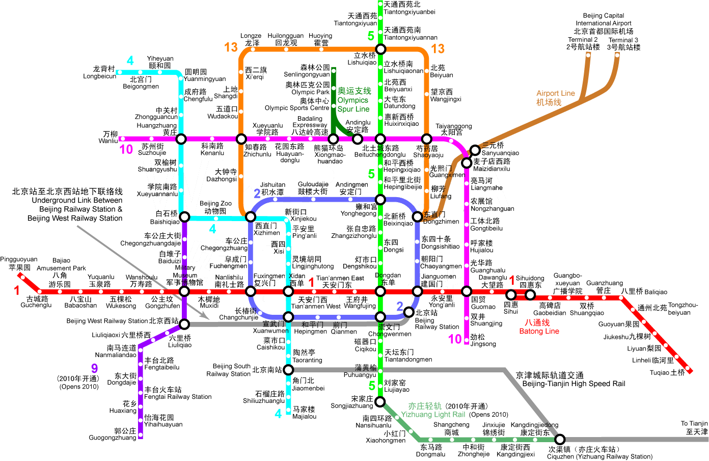
| This map showing the whole Beijing railway system is take from http://www.beijingholidays.net/image/image_bj/beijing-subway.jpg. As discussed in class, this is a kind of network map showing a topological space of a certain location - Beijing. It shows how different stations are connected to each other not by showing the absolute locations but the nominal and relative locations. The lines connect all the Beijing railway stations into an intricate but easy to read map which could easily allow people to get a sense of the space they are in and how to get from one station to another easily through the connections. This summer, I was traveling in Beijing with one of my other friend (who has also, like me, never been to Beijing). Each morning, we started off at Wangjingxi, a station on a orange "13" line. And in order to visit different landmarks including the Forbidden city and the Olympic village, we had to ask our friend who instructed us to get off at certain stations. For example, one time he told us to go to Fuxingmen on the red "1" line (from Wangjingxi) and it was really easy to get there simply by following the network lines to take the correct train. And then we realized that we had two options either going to the Dongzhimen direction or the Xizhimen direction because either way would take us there to Fuxingmen. This shows that how maps can allow us to make choices (route choices) just like what we do with a scaled map with our survey knowledge using shortcuts. This map, as compared to a more complex scaled map of Beijing, is much easier if we refer to the different railway stations as benchmarks. But at the same time it is also confusing because it does not have the cardinal directions and when we were traveling in the railway station, the signs would sometimes tell us to go to West or East direction. |
No comments:
Post a Comment